RESEARCH GROUP - ENGINEERING GEOLOGY & HYDROGEOLOGY
Team:
 |
 |
 |
 |
|
| BOZZANO Francesca | ESPOSITO Carlo | MARTINO Salvatore | MAZZANTI Paolo | |
 |
 |
|||
| PETITTA Marco | SCARASCIA MUGNOZZA Gabriele |
Topics:
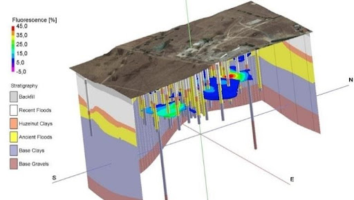 3D subsoil geological model integrated with geophysical sounding results supporting the characterization and remediation of a contaminated site
|
We carry out research in the fields of applied geology and hydrogeology, focusing on geoengineering, environmental and sustainability issues. We mainly deal with the analysis of different natural processes (e.g., landslides, earthquakes, floods, groundwater circulation) and human-environment interaction (e.g., pollution of soils and aquifers, soil-structure interactions), the geological applications of remote sensing, the availability and correct use of georesources. The forecasting and prevention of geological risks (geo-hydrological and seismic in particular), as well as the evaluation, enhancement and protection of groundwater resources are prominent research topics. |
|
As regards geo-hazard and geo-risk prevention, we develop methods and techniques for hazard and risk assessment declined at different scales, with a view to the transfer of research results to institutions in charge of land-use planning / management and civil protection. Research in hydrogeology is aimed at the qualitative and quantitative evaluation of groundwater resources in relation to anthropogenic pressure and environmental protection, in the context of variable climatic scenarios. |
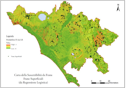 Landslide susceptibility map of the territory of the Province of Rome
|
|
Groundwater sampling for hydrogechemical characterization in South Africa
|
Our researches rely on geomatics and remote-sensing methods and techniques, numerical computation codes for the modeling of natural processes and the analysis of resulting scenarios, monitoring tools and Big Data analysis processes coming from recent installations in specially implemented on-site laboratories. We take part in national and international groups for research projects of various types and sizes, but we are also engaged in the "third mission", consisting of research contracts / collaborations with public and private bodies. Our research results are constantly published in high-impact international journals, placing our group in a prominent position in the panorama of the scientific community that deals with the topics described above. |

|
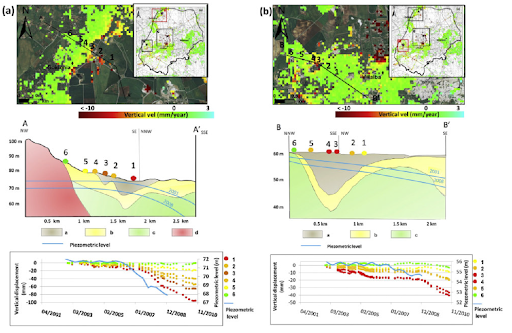
Example of the integration of engineering-geological, hydrogeological and remotely sensed data for the study of a subsidence process in the province of Rome |
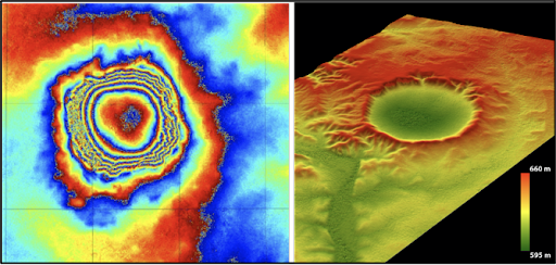 Satellite radar (SAR) data elaboration (left) and derived digital terrain model (right) of the Talemzane crater (Algeria) |